Braided River Tibet(Image credit: NASA)
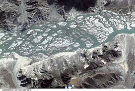
A recent NASA Earth Observatory satellite photo, featured in Live Science (October 2025), has drawn global attention to a remarkable yet worrying phenomenon in Tibet. The Yarlung Zangbo River, the world’s highest major waterway, appears to be changing shape more rapidly than ever before.
Stretching over 2,000 kilometers from the glaciers of western Tibet to India’s Brahmaputra River, the Yarlung Zangbo, known to Tibetans as the Tsangpo, is a lifeline for millions of people downstream. The new satellite images show an increasingly braided network of channels snaking across the plateau, splitting and rejoining in unpredictable patterns. Scientists attribute much of this to the impacts of climate change and glacial melt, but experts and observers are also raising alarms about human interference and large-scale infrastructure development in the region.
The Yarlung Zangbos dynamic, multi-channeled form is a natural characteristic of high-altitude rivers laden with sediment from nearby mountains. However, satellite data between 1988 and 2025 reveal that the rate of channel shifting, erosion, and flooding has increased sharply in recent decades.
Part of the cause lies in the rapid loss of glacial ice on the Tibetan Plateau, known as the Third Pole because it contains the largest reserve of freshwater outside the Arctic and Antarctic. The Angsi Glacier, the river’s source, has been retreating steadily due to rising temperatures, contributing to higher sediment flow and riverbank erosion.
But there is a more concerning trend that natural processes alone cannot explain: large-scale human activity and dam construction along the river’s course.
Since the early 2000s, the Chinese government has pursued an aggressive hydropower strategy across Tibet. The Zangmu Dam, completed in 2015, was followed by several others including Jiexu, Jiacha, Dagu, and the massive Medog hydropower project, all within ecologically fragile zones of the Yarlung Zangbo.
In 2021, China announced plans for a super dam near the Great Bend of the Yarlung Zangbo, a project expected to exceed even the capacity of the Three Gorges Dam. Scientists warn that such projects could alter sediment flow, increase erosion, and destabilize river channels, exactly the changes that satellite imagery now highlights.
Additionally, the rapid expansion of roads, tunnels, and military infrastructure in southern Tibet disturbs permafrost and soil stability, further influencing the river’s shifting pathways.
For local Tibetan communities, these transformations threaten not just ecology but cultural survival. Many sacred sites lie along the river, and traditional livelihoods depend on stable seasonal flows. The erosion and frequent re-channeling could wash away pastures and ancient settlements.
Downstream, the impacts may cross borders. The Yarlung Zangbo becomes the Brahmaputra River in India and Bangladesh, where millions depend on it for agriculture and drinking water. Unilateral damming and manipulation of the river upstream could have serious geopolitical and humanitarian consequences.
Moreover, the lack of environmental transparency in Tibet makes it difficult for independent scientists to study or verify these developments. As a result, much of what the world learns about Tibets environment comes from satellite data rather than on-the-ground research, a telling sign of restricted access and control.
The Yarlung Zangbos shifting channels are not just a natural wonder, they are a warning. What NASAs satellite captured is the visible imprint of a landscape under climate and political pressure.
Tibet, often called the Water Tower of Asia, supplies freshwater to nearly two billion people across Asia. The destabilization of its rivers is not an isolated issue; it is a global environmental concern.
As the images of this shapeshifting river circulate worldwide, they should prompt urgent reflection: How much of Tibets transformation is natural, and how much is being engineered?
The world must recognize that climate justice in Asia begins with transparency and accountability in Tibet.
References:
Live Science